One of the most important innovations in the outdoor recreation space over the past decade has been the development of portable, affordable satellite communication devices. These tools — like Garmin's InReach, SPOT, and ZOLEO — have saved countless lives and significantly increased the efficiency of off-grid emergency responses.
You don't need to search hard to find harrowing stories of mountain emergencies with positive outcomes thanks to these devices. Garmin recently released data on 10,000 SOS activations, and SPOT proudly showcases their "saves" online.
But there is a hidden complexity to these devices that rescue professionals know, but the public rarely sees. In some instances, the current technology adds inefficiencies — and even false alarms — to rescue efforts.
The Hidden Relay
Most users don't realize that satellite communication devices typically do not connect you directly to 911. In the case of Garmin and Iridium products, all SOS activations route to the International Emergency Response Coordination Center (now the Garmin Response Center). This is a private relay center that fields the signal, then works to coordinate your rescue with local agencies.
In many cases, this process works well. However, in remote emergency scenarios, time is the enemy.
In my own research, officials have reported the IERCC/Garmin Response relay adding over an hour to the response timeline. Remote rescues already battle time, weather, and terrain; adding a third-party relay agency to the logistics chain adds redundancy and friction to an already complex equation.
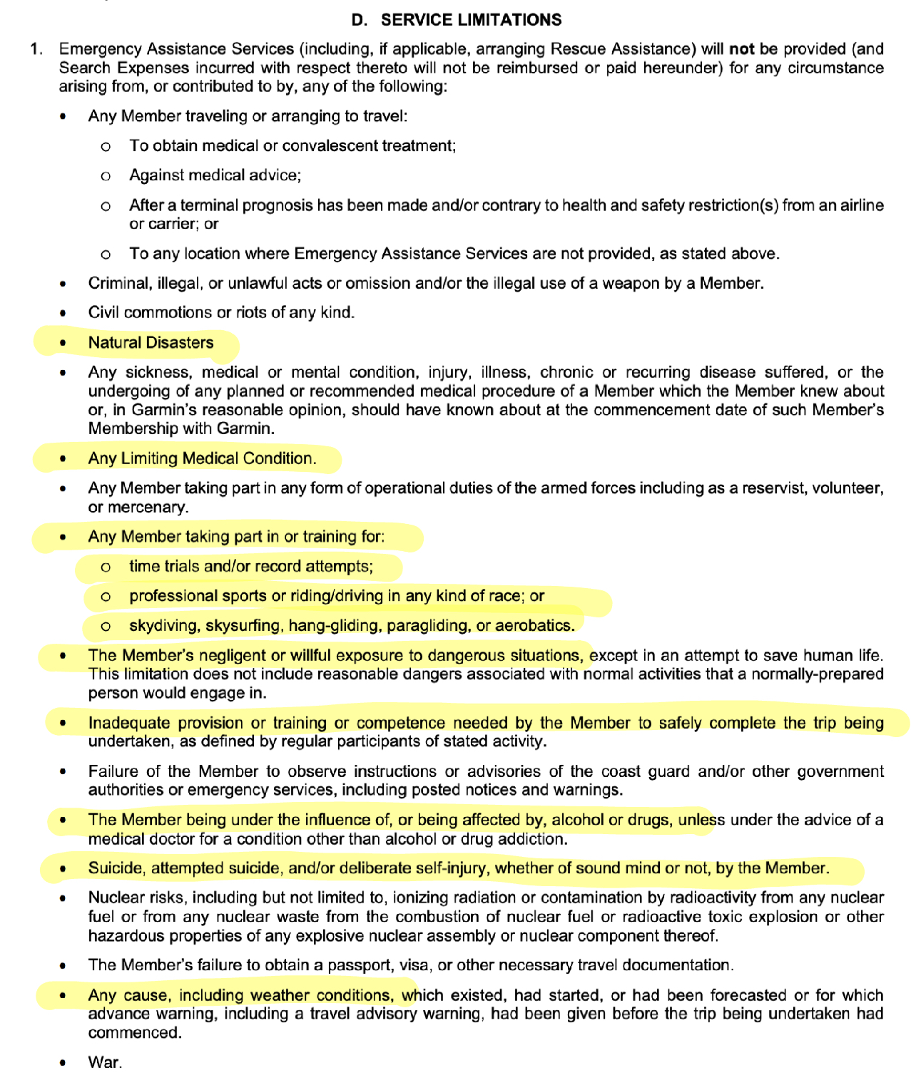
An excerpt from the IERCC Terms & Conditions
The Information Gap
In May, Jed Porter wrote a thorough review of popular SatCom devices for GearLab. It is excellent analysis, but I believe it missed the mark in one major way: Data Transfer.
The most critical question isn't just "Does the signal get there?" It is: "What information gets there, and how quickly?"
In my experience as a rescuer, I've found that rescue outcomes are positively correlated with the quality of information received early on. While current SatCom options are better than nothing, the industry has been waiting for a way to reduce response timelines through richer data.
Enter the iPhone 14 (and the End of the Middleman)
Over the last two years, I served as an advisor, subject matter expert, and UX researcher for Apple during the development of the Emergency SOS via satellite feature on iPhone 14.
While this feature isn't yet a 1:1 replacement for dedicated devices in every scenario, it possesses game-changing advantages that almost no one is talking about.
Direct-to-911 Routing
In areas where Public Safety Answering Points (PSAPs) support text-to-911 — roughly 70% of the U.S. — the iPhone routes directly to the local 911 center. It bypasses the private relay center entirely, utilizing the standard United States Text Control Center.
Rich Data Packets
The phone doesn't just send a "Help" ping. It collects critical data up front — high-integrity location, battery life, Medical ID, and the user's answers to a triage questionnaire — and blasts it to emergency services in the very first message.
This feat of engineering saves significant amounts of time. In one side-by-side field test in Arches National Park, the iPhone Emergency SOS delivered the user questionnaire to local dispatch, who then relayed it to a field ranger via radio, all in the time it took for two back-and-forth messages to be sent over an InReach Mini.
A ranger in Arches National Park tests the system end-to-end in a challenging canyon environment for sky-to-ground line-of-sight
"The greatest strength of the new iPhone feature isn't the speed of satellite connection or the simple user experience — it's the strategic and efficient delivery of critical information to the right agency."
Ubiquity
"Not many people have an InReach; everyone has a smartphone." This was a memorable quote during my research. The statistical advantage of putting life-saving technology into the pockets of millions — for free — cannot be overstated. The interface requires no setup; if a 911 call fails, the phone simply bumps you naturally into the satellite flow.
A ranger in Rocky Mountain National Park tests the system end-to-end with the local 911 center
Strategic Implications: The Gravity of the Shift
This transition isn't just about consumer convenience; it signals a fundamental restructuring of the outdoor technology market. For Product Managers, Designers, and Investors in the outdoor space, the integration of satellite comms into the iPhone ecosystem creates three immediate strategic realities:
- The "Good Enough" Competitor. Hardware manufacturers (Garmin, SPOT, ZOLEO) can no longer compete on basic connectivity. When "safety" becomes a free, native feature of the smartphone, dedicated devices must pivot to specialized performance — extreme battery life, ruggedization, 2-way messaging — to justify their existence. The baseline for entry has just been raised.
- UX as the Differentiator. Apple didn't just add a radio antenna; they solved the user interface of panic. They removed the friction of apps and logins during high-stress moments. Future hardware and software products in the outdoor space will need to match this level of intuitive design. If a user has to read a manual to send an SOS, the product is now obsolete.
- The Data Rush. For VCs and Founders, the value is shifting from hardware sales to data integration. The next unicorn in outdoor tech won't be a new dongle; it will be the software platform that best integrates this new flood of rich, real-time emergency data into search and rescue workflows, insurance models, and land management systems.
The Verdict: A Transition Period
So, what does this mean for my own kit?
I have owned multiple InReach devices and PLBs. They are well-built, robust tools. Having been the subject of a solo backcountry trauma emergency myself, I know intimately the value of that connection.
Currently, for the vast majority of my personal mountain pursuits, the iPhone's Emergency SOS gives me warm, fuzzy feelings. I know that if things go south, I can be in touch with NH 911 within minutes.
For professional applications, I still look toward dedicated tools for their battery life, tracking, and non-emergency messaging. The InReach is not dead. But it is clear that we are in a transition period. Very soon, off-grid satellite communication will be perfectly re-homed inside our smartphones — just like the map, compass, altimeter, and GPS unit before it.